The Case for a New Bridge Across the Waitematā
Garth Falconer – urban designer, Director of Reset Urban Design and author of ‘Living in Paradox: a history of urban design across kaianga, towns and cities in New Zealand’ (2015). Garth was the design team leader of the SkyPath project and originator of the SeaPath. He has researched over ten years the costs and benefits of the various alternative harbour crossings.
There is little argument that we need an additional Waitematā crossing and soon, not only to provide greater resilience as an emergency backup but also to expand our movement capacity and options. Particularly providing walking and cycling access across the central harbour which has been denied ever since the slimmed-down version of the Auckland Harbour Bridge opened in 1959.
In the space of a couple of weeks though, the Waka Kotahi/NZTA have suddenly ditched their design of getting pedestrians and cyclists across the Waitematā, saying it was unbuildable. Then they announced a second design was going to be a full-on stand-alone bridge just for walking and cycling on the east side of the AHB and it had a government-approved budget of $785m ($685 for the bridge and $100m for the access links). The mind-boggling 6 times increase has drawn huge taxpayer backlash against a hapless walking and cycling lobby. Leaving most feeling that this latest proposal is a desperate concession, hurried and inflated.
Unfortunately sitting alongside the AHB, the skinny width of the proposal will always make it look like just another add on. And its wide profile of neo-modernist flat steel panel sections will block out views of those iconic elevations of the AHB truss delicate structure. A series of private homes on Northcote Point will also have to be removed. Added to which, the Seapath now has been re-routed to sneak inland against the cliff with multiple crossings and up-close views of the motorway. Collectively what is called the Northern Pathway just seems like an orphan idea born of reactionary thinking.
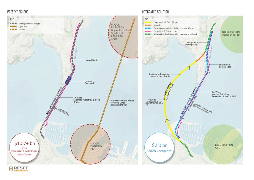
The other part of the movement equation is the incumbent tunnel which is the result of a whole raft of alternatives which were narrowed down in 2008. Since then, the tunnel has been solely embraced, refined and extended now to a 4km long eastern alignment taking off from the eastern side of Wynyard Quarter to pop up just short of Esmonde Road. The latest thinking from NZTA in November 2020 is that the tunnel must also include rail as the roading network on either end is saturated. And of course, the tunnel doesn’t cater for walking and cycling.
But the case against continuing with a tunnel option is huge; it will create devastating disruption to the central city’s waterfront on the CBD and on the ecology of upper Shoal Bay, the maintenance costs are massive and ongoing (calculated at $100 to 300m annually) the experience will be dark and enclosed for 4km underground. The killer is the costs to build the tunnel, which are so serious no one is brave enough to say, but acknowledged to be around the $10b mark and if there are possible blowouts such has been the experience with the CRL it will be with a tunnel.
With this complex situation, we have to understand the high-pressure predicament the Waka Kotahi are in pitched between competing interests and constraints but there is simply little case for proceeding with a separate pedestrian/cycle bridge and a tunnel.
There is however an alternative, and it is straight out of left field.
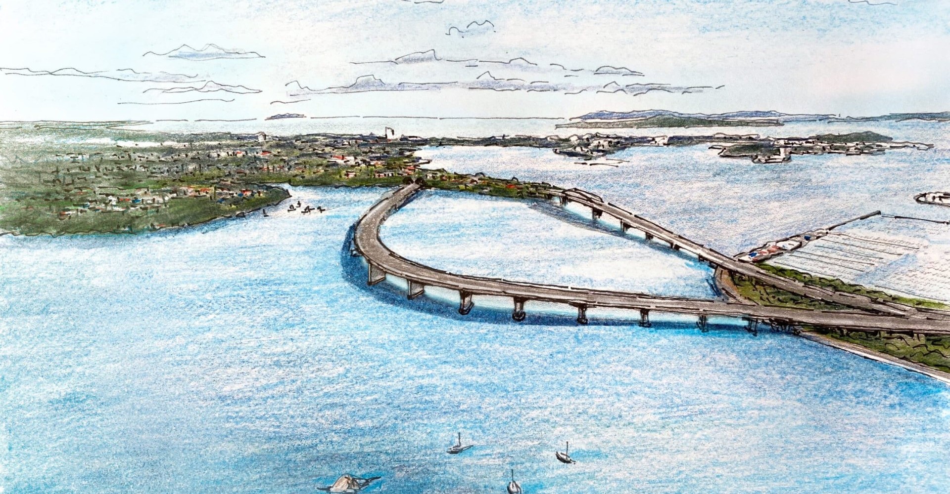
It is another bridge but not on the eastern side of the AHB which would crowd the iconic harbour scene. The idea started from thinking what would be the most beautiful way to cross the Waitemata and it was a simple line following a curve echoing the bay form of the coastline and reaching out into the upper harbour, giving space to the AHB revealing views with just a slim horizontal profile form
Engineering wise a new bridge to the west of the AHB carrying northbound traffic in tandem with reusing the AHB for southbound traffic provides simplicity and minimises disruption. This new bridge can extend out from Point Erin curve out to the west 500m and then back to pass through the narrow base of Northcote Point whose height of around 22 to 24 m is high enough to take a short tunnel (like the recent Victoria Park tunnel) to merge in with the existing lanes before Onewa Road off-ramps.
The new bridge needs to be 6 lanes perhaps including one lane for public transport (buses but eventually light rail which is the long-term answer to catering for increased commuter trips).
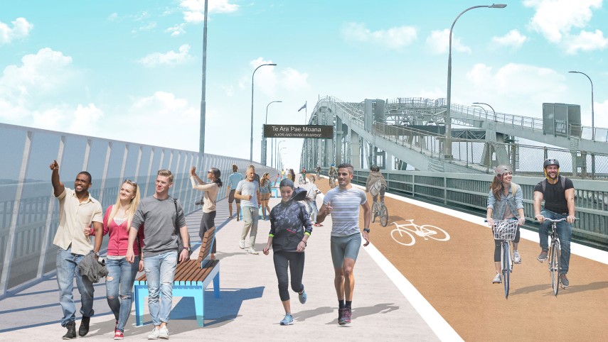
The rejigged AHB will support reduced traffic volumes which will aid its longevity and can accommodate a public transport lane, leaving 5 lanes for vehicles and 2 lanes for a wide generous walking, cycling, scooters and sightseeing. These 2 eastern lanes could be a high amenity feature pathway with planting, shelter, lookouts and seating like New Yorks High Line.
The new bridge would be constructed entirely on prestressed concrete which has very low maintenance costs and great longevity. Its form and costs would be similar to the recent Manukau Harbour Bridge though taller to allow for boat passage. The short tunnel would the accurately drilled in two separated sections by a road header similar to the Johnson hill tunnels near Puhoi – houses above would be retained just several would be removed on the northern side. The new bridge could be constructed within 5 to 7 years including design and would create minimal disruption to the CBD, the harbour’s ecology and operations of the AHB. The overall cost for the new 2 km long bridge would be $1.2bn (at $10,000m2 plus ramps) , $500m for the tunnel with AHB works and a healthy contingency the total would be around $2bn. Against current plans, that’s roughly one-fifth of the cost, less maintenance and a better result for all.
The challenge now is for all of us including the public, Waka Kotahi, Iwi, local and central government to come together to agree on and support the best way possible for an additional crossing of the Waitematā for the 21st century.